Dear digitalists,
In my last post, I shared a rather lengthy write-up of a geospatial data project I’ve been working on–I hope that some of it is helpful!
Aiming for brevity in this post (and apologies for hogging the blog), I’d like to see if anyone has feedback for part two of the mapping project I’m working on currently. To summarize the project in brief, borrowing directly from my last post: “Driven by my research interests in the spatiality of imaginative reading environments and their potential lived analogues, I set out to create a map of the Icelandic outlaw sagas that could account for their geospatial and narrative dimensions.”
While you can check out those aforementioned geospatial dimensions here, the current visualization I’ve created for those narrative dimensions seems to be lacking. Here it is, and let me describe what I have so far:
Click through for interactive Sigma map
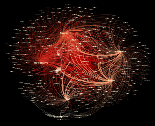
I used metadata from my original XML document, focusing on categories for types of literary or semantic usage of place name in the sagas. I broadly coded each mention of place name in the three outlaw sagas for what “work” it seemed to be doing in the text, featuring the following categories: declarative (Grettir went to Bjarg), possessive (which included geographic features that were not necessarily a place name, but acting as one through the possessive mode, such as Grettir’s farm), affiliation (Grettir from Bjarg) and whether the place name appeared in prose, poetry, or an embedded speech. Using open-source software Gephi, this metadata was transformed into nodes and edges, then arranged in a force algorithm according to a place name weight that accounted for frequency of mentions across the sagas. I used the JavaScript library Sigma to embed the Gephi map into the browser.
While I feel that this network offers a greater degree of granularity on uses of place name, right now I feel also that it has two major weaknesses: 1) it does not interact with the geographic map, and 2) I am not sure how well it captures place name’s use within the narrative itself.
My question to you, fellow digitalists: what are ways that I could really demonstrate how place names function within a narrative? Should I account for narrative’s temporal aspect–the fact that time passes as the narrative unfolds, giving a particular shape to the experience of reading that place names might inform geographically? How could I get an overlay, of sorts, on the geospatial map itself? Should I consider topic modelling, text mining? Are there potential positive aspects of this Gephi work that might be worth exploring further?
Submitting to you, dear readers, with enormous debts of gratitude in advance for your help! And even if you don’t consider yourself a literary expert–please chime in. We all read, and that experience of how potentially geographic elements affect us as readers and create meaning through storytelling is my most essential question.
Mary Catherine,
Wow. Just…wow. I love your project. Not just for the literary content, but also your technical skills. Did you have previous knowledge of any of these technologies or did you learn them all while undertaking the data side as well? Also, could you have translated the sagas from Old Norse? Seriously? Awesome. What you have done is really similar to one of the things I’ve been considering for my final project, although this puts my half-baked idea to shame!
Coming to this with no knowledge of the sagas, I found the maps to be most instructive. I spent a long time playing with the place name map. (None of the cities mentioned are in Iceland. Did Iceland not have a city at the time, or was everyone outlawed from the city?) The gephi graph is interesting, and I agree with you on the weaknesses. I’m also not sure what argument you’re trying to make by connecting place names with categories of use etc. As someone who is not a literary scholar, this network doesn’t tell me anything I can easily take away, as the maps do.
It is (I understand) possible to add lat/long coordinates to nodes in gephi and then use geo-specific layout (and plug-in to put it on an actual map) to express the network geographically. As a slightly map-obsessed reader, I would love to see each saga’s network of place names expressed this way. And if it were possible to make it chronological, so the edges appeared between nodes in the order they are mentioned in the saga, that would be amazing. It would merge the geographical and temporal aspects of the saga, and show me how the saga unfolds across time and space. Again, as someone who hasn’t read the sagas, this would be visually interesting, and instructive. For those who study these sagas, it might show new patterns or connections within each saga, or between them.
Of course, if some of the places were named but not visited, you would have to consider how (or if) to include them in this type of scheme.
I’m looking forward to seeing what direction you take this!
Sarah
Sarah,
Thank you so, so much for your excellent feedback! I think that linking the Gephi and the map would be a very useful experiment–I really appreciate you sharing that feature, and am grateful you took the time to give my project a thorough once-over.
As for my learning curve, last year I began this project in September with only a vague idea of HTML, and learned the rest from there. I was very fortunate to have a digital grant to incentivize learning all this new stuff and putting in the time–and I know CUNY has a lot of opportunities for that type of funding too. Might as well jump on into that water, right? I worked about ten hours a week for a year, so there’s a lot of learning behind each step of this project, I can promise you–and I’m still working on all this, to try and transform it into an article or some form of finished-for-now project. The work you all are accomplishing in less than a semester’s time is simply jaw-dropping.
And really, the most striking thing about these projects is just how much TIME they take–my idea was absolutely half-baked until almost the very end–so you give your project time to grow and be a little amorphous too, ya know! 🙂
I’ll keep you posted with what I find on that geo/Gephi.
Thanks again!
From an aesthetic and usability standpoint, what you’ve produced here is nothing short of beautiful.
Well done. Now off to go play with it for an hour.
Christopher,
Thanks for the kind words, and let me know what you find in your perusal!
I’ll swap some mapping skills for your wordpress skills! 🙂
I agree with Sarah and Chris that this is an impressive project and fascinating. In thinking about your request for ideas, I went back to the literary mapping that Moretti did. His maps derived meaning from the way the characters interacted with the places–what they did there, how often they went, their attitude about place. Is there a way for you to add that layer?
My second point is more of a question/clarification. Because of the age of the saga’s we don’t really know where the places are. Do I have that right? In fact, you suggest that we are not even sure if they were real places. I, based on nothing but whimsy, believe that they were probably real places. I think it’s really outside the scope of your project to utilize the descriptions of the places in combination with archeological records to speculate on where these (presumed) places were. That would be an interesting, but perhaps not a DH project.
Hi Mary Catherine,
Sorry for responding kind of late-ish, but it looks like you’re getting some great feedback from this project and, as I’m sure I’ve told you “irl,” I’m really really excited to see it come to fruition. If you ever need extra eyes on the finished article you’re writing, let me know! I’d be happy to read it. Good luck with everything! You’ve got some really great stuff going on.
All Best,
Sydnee