I recently attended a workshop on Map Warper at NYPL that dealt with ‘georectifying’, an often arduous and tedious post-digitizing processing of maps, that the NYPL Map Division has managed to turn into a fun and engaged activity by opting to crowdsource it. Funded by the NEH, the Map Warper is a tool suite, used by library staff but also open to the public, to align (or “rectify”) historical maps to today’s digital maps, adding valuable geographic context to old maps. Importantly, all work done is in the public domain. In NYPL’s words,
“Tile by tile, we’re stitching old atlas sheets into historical layers, that researchers can explore with pan-and-zoom functionality, comparing yesterday’s cityscape with today’s. Along with other tools — such as one for tracing building footprints and transcribing address and material information found on the maps — we are laying the groundwork for dynamic geospatial discovery of other library collections: manuscripts and archives, historical newspapers, photography, A/V, ephemera (e.g. menus) etc.”
Given our discussions these past weeks, it seems to me that the points of departure are numerous. I’m reminded of Sarah’s post on mapping the urban setting of fictional characters, when I think about how this tool can help recreate the urban setting of historical characters/personages in today’s context. All one needs is a time period and location, if the Map Division has a corresponding map, lo, and behold! you can see the past and present streetscapes simultaneously. From an urban planning perspective, it is fascinating to see how the cityscape wears the passage of time and explore possible lessons for urban design. I expect it also will help planners visualize and chart the imperceptible movement of real estate, the steady shift of the cityscape over the underlying landscape, which is only possible with tools such as this.
Source: Map Warper, NYPL Labs
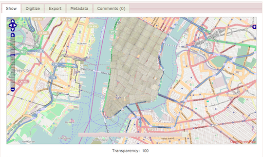
“The above image shows a warped map sheet from an 1857 William Perris Real Estate Atlas depicting a section of Manhattan to the southwest of Union Square (see it in the context of the Warper). By stitching this to its sibling sheets from the atlas, we can build a complete 1857 historical layer of Manhattan, observing changes in the street layout and conjuring the ghostly footprints of old buildings. This is just step 1 in a larger integration effort, in which we can pull together archival records, newspapers, photography and other literary and historical documents that are associated with places on the map.”
Link – http://maps.nypl.org/warper/
For those of you interested, there is also a helpful tutorial video on their website to get you started on the project, and helpful Map Division staff are available for tech support.